 SRTM Terrain Importer
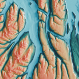
Import SRTM elevation data as accurate 3D terrain.
Version History
1.0.5
Blender 4.2
and newer
- 6.5 KB
- 3549
-
February 22nd, 2025
No changelog for this release.
Approved
1.0.4
Blender 4.2
and newer
- 6.5 KB
- 11
-
February 22nd, 2025
Changelog
Tag fixed
Approved
1.0.3
Blender 4.2
and newer
- 6.5 KB
- 14
-
February 22nd, 2025
No changelog for this release.
Approved
1.0.2
Blender 4.2
and newer
- 6.6 KB
- 13
-
February 22nd, 2025
Changelog
- Minor bug fix
Awaiting Review
1.0.1
Blender 4.2
and newer
- 6.5 KB
- 11
-
February 22nd, 2025
Changelog
- Minor bugs fix
- Drag and drop support
Awaiting Review
1.0.0
Blender 4.2
and newer
- 6.2 KB
- 17
-
February 9th, 2025
Changelog
Import SRTM 1 arc-second (30m) elevation data as 3D terrain Accurate geographic dimensions based on latitude Real-world elevation values Adjustable vertical scale Choice of color schemes (natural terrain or grayscale) Automatic UV mapping for texturing Displacement-based mesh detail Metadata storage (coordinates, elevation range, dimensions)
Awaiting Review